
Bank Holiday Weekend Set for Turbulent Weather as Storms Sweep Across England and Wales
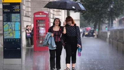
Traveloasisspot.com – The long weekend ahead promises a volatile mix of sunshine, downpours, and thunderstorms across much of the British Isles, according to the Met Office. After a stretch of record-breaking heat and drought conditions that gripped large swathes of the country, forecasters are warning that Thursday will bring a significant shift in the weather pattern, with potentially intense convective activity moving northward from the south.
Two separate yellow thunderstorm warnings have been put in place for Thursday. The first covers London and the South East from 2 a.m. through 8 a.m. The second, considerably broader in scope, spans Wales and much of England from 5 a.m. until 10 p.m. Together, these alerts signal that residents across a wide geographic area should expect lightning, hail, and periods of very heavy rainfall within a compressed timeframe.
What the Numbers Mean for Thursday
Forecaster Craig Snell explained that parts of the larger warning zone could accumulate more than 75 mm of rain within a twelve-hour window, while the South East alert area faces 30 to 40 mm alongside what he described as “fairly large hail between 1-2cm.” Temperatures will remain elevated despite the storm activity, with daytime highs reaching 27 or 28 degrees Celsius before the system passes.
For context, 75 mm of rain in a single day represents roughly the average monthly total for many parts of southern England compressed into a single afternoon. Roads, drains, and low-lying properties are particularly vulnerable at that intensity, especially where preceding dry spells have left soil compacted and less able to absorb water.
Birmingham Already Feeling the Impact
The threat is not purely theoretical. West Midlands Fire Service confirmed on Wednesday evening that crews were dispatched to what it termed “significant flooding” affecting Curbar Road, Thornbridge Avenue, and Haddon Road in Birmingham. The service noted that West Midlands Police and Birmingham City Council were providing on-scene support and urged residents to avoid the affected streets where possible.
The city council separately issued guidance advising the public to “take care and avoid walking, cycling or driving through flood water,” a reminder that even shallow standing water can conceal open manholes, debris, or electrical hazards.
The Weekend Outlook: Unsettled but Not Continuous
Looking beyond Thursday, the pattern remains choppy. Friday will see additional heavy rain and thunderstorms traverse the UK. Saturday brings further rain, while Sunday and Monday are expected to offer a patchwork of sunshine interspersed with showers. Daytime temperatures will retreat toward seasonal norms, easing to 24 or 25 degrees on Friday and settling at 22 or 23 degrees through Monday.
“To sum up the bank holiday weekend, it’s going to be pretty unsettled, there will be some sunny moments in between if you can dodge the downpours. It’s not going to be a complete washout, if you’ve got outdoor plans over the weekend, keep a close eye as there will be rain moving in across most parts.”
Snell added that the immediate risk on Thursday morning involves a band of potentially heavy, thundery rain stretching across parts of the country as people wake up, with the Midlands and Wales facing what he characterised as “quite a wet day really.” Additional thunderstorms were expected to push into the South East around Thursday evening.
Aftermath of a Record-Breaking Summer
The stormy weekend arrives in the wake of an extraordinary summer. Five distinct heatwaves swept the UK this season, pushing temperatures to 38.1 degrees Celsius in London and placing the country on track for its hottest summer on record. Those same hot spells coincided with extremely dry conditions, prompting drought declarations across nearly three-quarters of England and the entirety of Wales.
The contrast between weeks of parched ground and the prospect of intense, short-duration rainfall creates particular hazards: compacted soils shed water rapidly, increasing surface runoff and the likelihood of flash flooding in urban areas. Communities that have endured weeks of water restrictions and fire-risk warnings now face the opposite challenge of managing sudden, concentrated precipitation.
Residents planning outdoor activities over the bank holiday weekend are advised to monitor updated forecasts, avoid low-lying routes during peak rainfall periods, and allow extra travel time. The combination of warm air, high moisture content, and convective instability means that even brief pauses between showers can give way to rapid re-intensification of storms.
Related Reading
Frequently Asked Questions
What is Warnings for thunderstorms before mix of rain?
Warnings for thunderstorms before mix of rain is the main topic of this guide. The article explains the context, practical details, and next steps readers should understand.
Why does Warnings for thunderstorms before mix of rain matter?
Warnings for thunderstorms before mix of rain matters because readers are looking for a useful answer, not just a short summary. Good content should match search intent and help them decide what to do next.