
Severe storms with intense tornadoes possible in Central US through Monday
Severe storms with intense tornadoes possible – May has typically been a month of frequent severe thunderstorm outbreaks in the Plains and Midwest regions, but this year’s weather pattern has been unusually calm. That could change quickly as a volatile atmosphere is now set to deliver a significant storm event across the central United States. The National Weather Service has issued warnings for the possibility of powerful tornadoes, destructive hail, and heavy rainfall, with the most dangerous conditions likely to peak on Sunday and Monday. This shift is attributed to a change in the jet stream’s behavior, which has allowed for a surge of instability to build in the region.
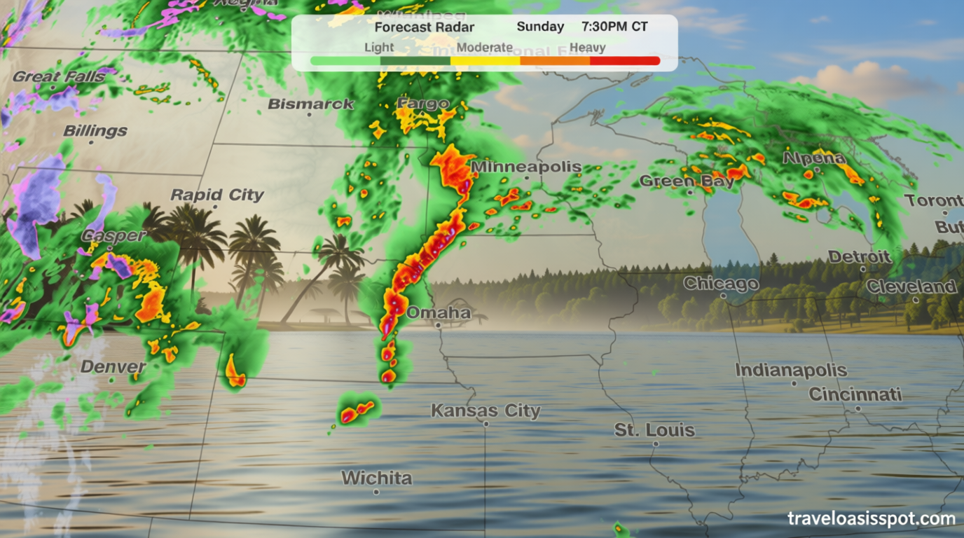
Storm development and timing
Severe thunderstorms are expected to rapidly intensify during the late afternoon and evening hours on Sunday, particularly over Nebraska and southeastern South Dakota. These storms will bring the risk of large hailstones, with some reports indicating the potential for hail as big as golf balls. The most critical tornado threat will emerge between 4 p.m. and 10 p.m. Central Time, targeting eastern Nebraska, southeastern South Dakota, and western Iowa. Cities like Omaha, Lincoln, and Sioux City are in the crosshairs, with forecasters urging residents to monitor weather updates closely.
As the week progresses, the storm system will expand further, leading to widespread severe thunderstorms on Monday. This surge is driven by the jet stream’s increased energy interacting with ample moisture in the Plains, creating ideal conditions for tornado formation. Supercells—rotating thunderstorms—may develop in the afternoon, potentially spawning EF2 or stronger tornadoes. While the primary danger will shift to damaging winds and hail by late evening, a few tornadoes could still occur into the early hours of Tuesday.
Wildfire risk in the Southwest
“Sustained winds of 25 to 30 mph, gusts up to 50 mph and relative humidity under 10% will combine with dry fuels causing any fires that ignite to spread at a life-threatening pace,”
Meanwhile, the same weather system that fuels severe storms in the Central US is also contributing to dry and windy conditions in the Southern High Plains. This has elevated the risk of wildfires across Arizona, New Mexico, and parts of Texas. The National Weather Service has classified the fire threat as extremely critical on Sunday and Monday, with the highest danger in southwestern Kansas, the Texas Panhandle, and northeastern New Mexico. A broader critical threat extends to much of New Mexico, where fire conditions are expected to remain hazardous.
The combination of high temperatures, low humidity, and strong winds creates a dangerous environment for wildfires. Dry vegetation, exacerbated by the lack of recent precipitation, is primed to catch fire quickly. Firefighters are preparing for potential outbreaks, especially in areas where dry fuels are most concentrated. The storm system’s movement will bring some relief to the Southwest, but the threat remains high until the fire danger subsides.
Shift in storm patterns on Tuesday
By Tuesday, the focus of severe weather will begin to shift eastward. Thunderstorms are anticipated to persist in the morning, stretching from northern Texas to Michigan. However, the intensity of the tornado threat will decline as a cold front becomes the dominant trigger for storm development. This change will reduce the likelihood of tornadoes but increase the risk of damaging winds and hail, particularly in the afternoon.
Although the tornado threat diminishes on Tuesday, the region will still experience strong storms that could produce significant weather impacts. Forecasters warn that the transition from tornado activity to wind and hail dominance is not abrupt, and some isolated tornadoes may still occur in the late evening. The timing of these storms will depend on how the morning’s cloud cover interacts with the afternoon’s atmospheric conditions, which could influence the strength of the supercells.
Regional variations and preparedness
While the Central US faces the brunt of the storm activity, the Southwest’s fire risk highlights the diverse weather challenges across the country. The same system that brings extreme conditions to the Plains also creates a tinderbox in the arid regions of Arizona and New Mexico. Residents in these areas should take precautions to prevent wildfires, such as clearing brush and ensuring access to water sources.
For those in the path of severe thunderstorms, the importance of early warning systems cannot be overstated. Tornadoes can form rapidly, often without much notice, and the timing of the most intense activity—between 4 p.m. and 10 p.m. CT—requires heightened vigilance. Weather alerts will be crucial for informing the public about changing conditions and potential hazards. Additionally, the interaction between storms and fire risk underscores the interconnected nature of weather patterns and their impact on different regions.
As the storm event unfolds, meteorologists will closely monitor the evolution of the jet stream and the moisture levels to refine their forecasts. The potential for EF3 or stronger tornadoes, paired with the risk of wildfires, means that the coming days will test the region’s preparedness for extreme weather. Whether it’s a tornado warning or a fire alert, staying informed and taking action is key to minimizing damage and ensuring safety.
Residents across the affected areas are advised to review their emergency plans, secure outdoor items, and remain alert to changing weather conditions. The National Weather Service will continue to provide updates throughout the week, helping communities prepare for the different phases of this weather event. With the potential for widespread impact, the Central US and the Southwest will need to balance their focus between tornado preparedness and wildfire mitigation as the storm system progresses.
